ABN 23-465-330-354
Home Museum History Membership Publications Photographs Research Genealogy Journal & Stories Events
Moruya A Short History by Stuart Magee
A pdf file of the text of this document can be downloaded here.
Aboriginal Moruya
White Settlement
Between the Two Rivers
South of the Moruya River
Agriculture and Timber
Gold and Granite
Tourism and Sea Change
Acknowledgements
Aboriginal Moruya
Archaeological work along the south coast of NSW has uncovered Aboriginal sites dated up to 20,000 years ago, although work around the Moruya area has not revealed sites older than 4,000 years. That, however, cannot be taken as an indication of late settlement of the area - the archaeologists believe that earlier sites along the coastal plain were covered by silt. One of the oldest and more important sites in the area was found at Broulee.
The main tribe of Aboriginal people, ranging along the coast from Cape Howe to the Shoalhaven, was the Yuin tribe. The branch of that tribe in and around the Moruya area was the Bugelli-Manji clan. When white settlement commenced at Moruya the people living at Mullenderee - the flats beside today's Princes Highway on the north bank of the river - referred to themselves as the Burgurgo or Pergoga people. The spelling varies in the documentation left from that time.
The numbers of Aboriginal people living in the area before white settlement is difficult to ascertain. In 1833, five years after the arrival of the first local settler, a formal return of the Aboriginals who had been present at a property of four square miles at Mullenderee on 8 October recorded 66 people - 25 men, 19 women and 22 children. The usual places of abode of those people were recorded and included Broulee, Moruya (the south bank of the river), Kiora, Araluen and Bergalia. A later report, in 1845, dealt with the Aboriginal population of the Broulee Police District which ran from St. Georges Basin to the north bank of the Moruya River. It was estimated that about 250 Aboriginal people were living in that area at the time. The writer of the report estimated that about twice that number had been living in the area 5 to 10 years earlier, and suggested that the dramatic reduction of their numbers had been due to cutaneous and venereal diseases.
There is one informal report, probably at least second-hand but from a reasonably credible source, which was published in 1888 and suggested that over 1,000 Aboriginals had been seen camped around the Moruya Lagoon on some earlier occasion. They may well have gathered from quite a wide area in order to attend a special meeting.
The livelihood of the local people depended more on fish and shellfish than red-blooded meat. Their shelters were rough and possum skin cloaks were the usual source of warmth and protection in winter. Physically they were very able, and there are first-hand accounts of the boys practising their spear throwing on rough bark discs bowled erratically along the ground. They achieved great skill.
The family unit was the main social building block, though the concept of 'family' was flexible. Groups of families were controlled and directed by a headman. The eminent anthropologist A.W.Howitt says the term used by the Yuin for the headman was the 'Gommera'. Just how the Gommera came to assume his position is not entirely clear but it does seem he needed to be respected as a hunter and a warrior. He was wise, he had magical powers and he had spiritual connections.
The Gommera also presided over justice. Howitt, writing in 1883, had this to say :-
"Among the Yuin there was the same practice of expiatory ordeals as among the other tribes I have quoted and the old men prefer this to armed parties being sent out to exact blood-revenge in a feud. The kindred of the deceased frequently revenged themselves by lying in wait for the suspected person, and killing him when out hunting alone. This naturally led to reprisals, and thus to complications such as those which caused the great blood-feud in the Kurnai tribe."
"An instance is known to me of an expiatory meeting in the Yuin tribe in consequence of a Moruya man being killed by a man from Bodalla, but I am not aware whether by violence or by magic."
"The Bodalla Gommera sent a Jirri (messenger) to the Bodalla man, telling him he must come to a certain place and stand out. Meanwhile the men of Moruya were preparing their spears and heating their boomerangs in hot ashes to make them tough. At the time fixed, the man appeared, armed with two shields. As he was charged with killing someone, he had to stand out alone; but if he had been only charged with injuring him, or with having used Joias, that is, magical charm, without actually killing the person, he would have been allowed to have a friend to help him. His friends with their Gommera stood at one side, a little out of spear range, while the Moruya men and their Gommera were at one side of the friends of the dead man."
"It having been arranged how many of the fathers and brothers (own or tribal) of the dead man should attack the defendant, the Gommera then told them what to do, and they went forward towards the Bodalla man, who stood alone expecting them. At about 30 yards distance from him they halted for a while to give him time to prepare himself for defence, then standing in a line facing him, they threw their boomerangs and then their spears at him. He being wounded, his Gommera shouted out 'Jin ail', that is, 'Enough!' and they ceased. There was no further action in this matter, for blood had been taken."
Of particular interest to the Broulee area are the transcripts of the interviews Janet Mathews recorded in 1965 when speaking with three well respected local Aboriginal men - David Carpenter, Herbert Chapman and Percy Davis. The three men stated that the tribe or clan or family that lived on Broulee Island was different to the one at Moruya. Percy Davis, whose tribal name was Narramurrao, was the last link with the language of the Yuin people. Percy died at Moruya in 1968. The publication of the book "Dhurga Dictionary and Learner's Grammar. A south-east coast, NSW Aboriginal Language" by Patricia Ellis, Kerry Boyenga and Waine Donovan in 2020 has ensured the continuation of the language.
For further information on the local Aboriginal community see Eurobodalla Shire Council web site's Aboriginal Culture Page at https://www.esc.nsw.gov.au/community/Arts,-culture,-and-heritage/aboriginal-culture
Back to Top
White Settlement
Between the Two Rivers
White settlement along the coast south of Wollongong was fairly slow and sporadic by comparison with the areas north, west and south-west of Sydney, ie the Hunter River Valley, Bathurst and beyond, and Goulburn. The search for good land for farming or investment was vigorous and kept moving ahead of the resources of the Colony's surveyors. By 1823 all available land in the strip bounded by Sydney, Penrith, Windsor and Appin had been taken up and the push outwards was well under way. Within the Limits of Location title to land could be obtained, usually in lots of 640 acres or one square mile to a limit of four square miles. Beyond the Limits of Location a licence to squat could be obtained but not title to the land. Up until 1828 the southernmost limit to settlement was the north bank of the Clyde River. However, in 1827 and 1828 surveyors were sent to map out the area further south.
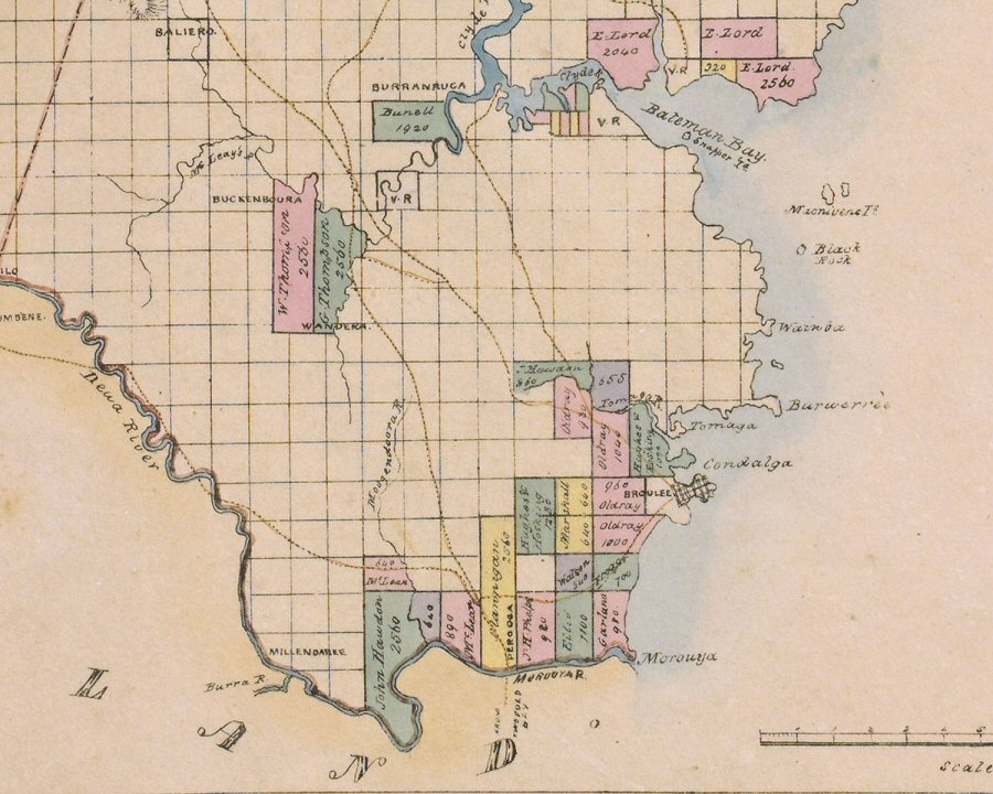
Moruya was approached from two directions. Settlers moving south from Goulburn to Braidwood were looking for further opportunity and in 1827 H.S. Badgery and Henry Burnell took up a position in the Araluen Valley. Part of the brief to surveyor Robert Hoddle was to continue on from that point and follow the Deua/Moruya River to its mouth. He did that and then moved north to the Buckenbowra river where W and G Thompson had established a squat on four square miles and Burnell had another place of 1920 acres further down stream. In 1828 another surveyor, Thomas Florance, was sent down the coast to Batemans Bay, on to Broulee and to the Moruya River. It was he who adopted the Aboriginal names for Broulee, Tomakin, Candlagan Creek and Moruya, though his spelling of those names was subsequently modified.
Thus, in 1828 the southern boundary of the Limits of Location was moved to the north bank of the Moruya River. The same administrative action established the County of St. Vincent which ran from the Shoalhaven to the Moruya River. Surveyor Hoddle offered his opinion on the future prospects for the County. "It is very barren" he said "at least nine tenths of it will be suitable for no purpose whatsoever."
The first man to obtain a grant of land on the north bank of the Moruya was B.G.Raye. It is doubtful if he ever saw the block and he did not settle on it. The first settler was Francis Flanagan, an Irish tailor with a little capital, plenty of gumption, but a habit of getting at cross purposes with his neighbours and the Colonial administration. Nevertheless, he performed duty over a number of years as a local magistrate, census taker and distributor of government blankets to the Aboriginal people. In 1829 he was granted title to four square miles on the north bank of the river. It extended on either side of today's Princes Highway along the flats. The area was referred to by him variously as Nullandarie - today's Mullenderee - or Pergoga - a name he spelled at least three ways and which appeared on the maps of the time but has since disappeared. His property and homestead he called Shannon View. By 1838 he claimed to be running 800 cattle, 12 horses and 200 pigs.
Flanagan was followed by John Hawdon. Hawdon had arrived from England in 1828. He had property at Sydney and in 1830 set up a squat at Bergalia but, being beyond the limits, could not gain title to the land. In 1831 he was granted land on the north bank of the river, upstream from Flanagan. He called the property Kiora and it too occupied 2560 acres or four square miles.
By 1840 the rest of the river flats land running along the north bank had all been claimed. Lt Col Phelps bought 940 acres on the eastern side of Flanagan. However, Phelps died within the year and the property was sold to James Staunton. James Ellis, a naval surgeon, bought 1100 acres on the eastern side of Phelps, and the remaining land, 980 acres between Ellis and the north head, was bought by James Garland. He, however, had it subdivided into a group of blocks marketed as Garland Town. The project failed but the name stuck to the area. In 1838 John Maclean bought Raye's block and added a further 890 acres to it forming the third largest run on the north bank. He called it Glenduart.
Across the river, opposite Flanagan, William Morris, in 1835, squatted a block he called Gundary. William Campbell took up as manager and bought the place himself in 1845.
These people were raising stock and growing crops but they had a significant problem in getting their produce to the Sydney markets. The Moruya River, while it offered a fine means of punting goods and chattels between the properties on the river bank, had a bad bar at the mouth and was chancy for boats big enough to ship goods to and from Sydney. As a result, in 1836, John Hawdon wrote to the Governor pointing out that the local farmers were dependent on Broulee Bay as their local port and its use as such was handicapped until Broulee was surveyed. In the meantime goods would continue to be moved between ship and shore by small boats but he himself was keen to build a wharf and store on Broulee beach as soon as he could obtain suitable land.
Surveyor Larmer was set to the task and in 1837 his lay-out of the Village of Broulee was Gazetted. On the Island it included eight streets and 55 blocks. On the mainland it laid out the area bounded approximately by Clarke to Albert streets and by Massey street to Harbour Drive.
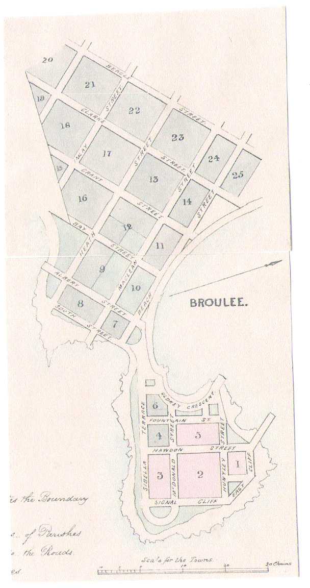 'Broulee Island Sub-division (roads were never made and the Island was declared a Nature Reserve in 1972)'
Once more the prognosis offered by the surveyor was not encouraging. In writing to the Colonial Secretary the Surveyor-General advised: "Browlee, which may be called East and West Browlee, being divided in two parts by a narrow neck of sand subject to be overflowed by very high tides, appears not to possess any favourable features for the formation of a town. The harbour is too open and the space for laying out streets is limited.---- the place seems too unimportant for any considerable expenditure on the erection of public buildings and without them a town would never be formed."
That, however, was not the way the speculators saw the prospects for Broulee, though neither John Hawdon nor anybody else ever pressed ahead with the notion of building a jetty and store, other than a very minor jetty for shell grit in the 1920's.
First in was the firm of Hughes and Hosking. John Hughes and John Hosking were both related to Samuel Terry, one of the biggest money men in Sydney, and their partnership was the biggest land holder both in NSW and the settlement of Port Phillip. They picked up an 1170 acre block at the north end of Broulee beach including all of Mossy Point as it stands today. In addition, they had two 640 acre blocks to the west of the Village, and when the Village lots went on sale in 1840 they took 12 of the blocks on the Island. However, neither Hughes nor Hosking made any move to settle in the area and when the economic collapse of 1841 to 1844 arrived they featured as the Colony's most catastrophic bankruptcy.
The other big mover into Broulee was Captain William Oldrey. In four lots of up to 1110 acres he acquired 4010 acres butting up to the Village along the whole of its southern and western boundaries. In the auction of the Village sites he picked up three blocks on the Island. Oldrey had been pensioned off from the navy. He was keen to speculate on Broulee and was not averse to putting his efforts into the development of the place. He built his home, Mt Oldrey Estate, on the western slopes of Broulee, running on both sides of today's Broulee Road down to the beach, but put it on the market within the year. His lengthy advertisement in the Australian, in its description of the homestead, the infrastructure of Broulee and the boom that was about to arrive, was, to put it as kindly as possible, 'enthusiastic'. The collapse of 1841 on its own would probably have been enough to take out the over-stretched Captain, but it coincided with another event which took its toll on Broulee. In 1841 heavy rain and the consequential flood of the Moruya River washed out the bar at the mouth, opening it up to coastal shipping. The farmers on the river were delighted at the prospect of avoiding the trek to and from Broulee Bay by way of rough bush tracks. It was the beginning of the end for Broulee.
The first wave of settlers and speculators following the surveys of the land between the Clyde and the Moruya rivers was largely complete by 1841. It was to be a while before further moves of any consequence took place for the investors of Sydney town were awash with tracts of land unsaleable at any price.
The following map from Baker's Atlas of 1843 to 46, published with the kind permission of The National Library of Australia, shows the main holdings between the rivers at the time. The grid on the map is in square miles based on magnetic north - the basic building block of the Colonial surveying and granting of land.
Click for larger image
It was a frail settlement, clinging to hope, battling with the Australian bush, with a lack of support from Sydney, and floods and fires the likes of which were unknown to people from Britain. Nevertheless, some of the early settlers were determined to make something of the place. Hawdon and Oldrey were particularly busy and badgered the Colonial Secretary to have Broulee set up as the centre of a Police District, the place for a Court of Petty Sessions and the centre for convict administration. They were successful and in 1839, at Broulee, the Police Station was established with three constables and the Court was set up with Oldrey and Hawdon as its magistrates. Later, Francis Flanagan, William Campbell and others were added to the Bench. There was a Clerk to the Court, a Scourger and a Pound Keeper/Postmaster. On the Island the Erin-go Bragh hotel was built.
But, for all the beating of drums, it was not a significant place. The census of 1841 recorded that Broulee contained 6 buildings and 46 people, 40 of whom, including convicts, were working for Oldrey. In 1848 Broulee contained four buildings and 22 inhabitants. Up the Moruya River, the 1841 census recorded 40 people on Hawdon's place, 39 on Flanagan's and 34 at Maclean's. Hawdon had 35 convicts working for him and Flanagan had 19, but the assignment of convicts ceased in 1840 and there was no transportation from the following year.
Back to Top
South of the Moruya River
South of the Moruya the squatters had continued to squat. Both those who were licensed and those who were not were a constant problem for the Colonial administration. Ultimately, what was to happen to the land they occupied? Would they finally acquire it simply by allowing time to weary the opposition? What of other people who had been more orderly (or less venturesome, depending on which side of the argument one wished to push) and were still waiting their chance? It all got sorted out by a succession of systemic changes which go well beyond the scope of this note. However, as an instance, Governor Gipps' Imperial Wastelands Act of 1842 provided that squatters might obtain ownership of one square mile surrounding a homestead they had constructed. The rest of the land they had occupied could be leased to them but later go to public auction when the Government felt the time ripe. Sometimes this worked well for the new settlers. But sometimes it worked well for the squatters. They had the means to out-bid others for the best of the run. People who then set out to farm the poorer blocks tended to fail and desert the block, leaving the squatter in control by default. This system lasted but five years to be replaced by the next administrative scheme, but it serves to illustrate the problem and the causes of some considerable discontent.
In Broulee, the discontent flowing from squatting found a spokesman in William Willmington, a storekeeper who, having fallen for Oldrey's tall tales, had set up a store at Broulee and was going broke. Not a happy man. He wrote to the Governor and complained about three of the squatters : -
"The first Station on the banks of the Moruya River, which divides the Territory of New South Wales from Port Phillip, is taken as a Squatting Station by Messrs. Abercrombie & Co., Distillers, Sydney, carried on by a Mr. W. Campbell as Superintendent (who as a matter of course was appointed a Magistrate). This Station contains 32,400 acres --- employing from 12-15 men. The second Station adjoining is 'Brigalia,' about the same in extent, and also held by Abercrombie & Co. This employs from 8-10 men. The third Station 'Boat Alley', held by Mr Hawdon JP, contains about 64,000 acres employing from 12-15 men. The last in this neighbourhood called 'Bigga' is taken by a Mr George Imlay, JP. It consists of 960,000 acres giving employment to about 100. The men employed by these Gentlemen are principally convicts. Here is an extent of land equal to a 30th part of England and Wales, the greater part admirably fitted for agricultural purposes, occupied by three persons, for which the enormous yearly sum of sixty pounds is paid."
The squat which was to have a marked effect on the development of the Moruya area was John Hawdon's at Bodalla or the 'Boat Alley' referred to by Willmington. Hawdon had got out of the Bergalia lease which became attached to the Gundary property forming a large holding which was acquired by Henry Clarke. Clarke was an influential man in the development of the district and represented as Member of Parliament for Moruya and Bega for 25 years.
Hawdon's attention was focussed on Bodalla, where he had a nice block of 13,000 acres, but he needed to borrow heavily to finance the purchase. He borrowed from the entrepreneur, Thomas Sutcliffe Mort. Mort entered into a partnership with Hawdon. They carried on for a while but, in the end, Mort bought Hawdon out and took over the property. Before he was done the place ran to 56,000 acres. He set about managing the property along what were described as 'model farm' lines.
Mort was an unusual man. He had high Christian principles, an excellent grasp of business and finance, means, and a number of financial successes to his name. He had a stylish residence at Darling Point. Yet it was the project at Bodalla - a most uncomfortable journey from Sydney - which increasingly absorbed his attention, his means and his ambitions. He set out to attract share farmers or farmers who wanted a small holding in this area for which he had established his objectives and plans. He imported good stock and good seed for grass and grain. He encouraged hard work, sobriety, church going and a community spirit, At first he concentrated on wheat and other grains. It was successful until the rust practically wiped out the wheat. Dairying, cheese and pigs, using the latest and best techniques then became the main focus. It was successful and there was employment or a business for over 300 men. The Mort family created the village of Bodalla itself and left to it both the Anglican and the Catholic churches. The name 'Brou', as in Brou Lake and Brou Beach also came from the Mort family. It came from a family association with a place in Belgium and has no connection with the Aboriginally derived 'Broulee'.
Meantime, small tenant farmers working on Flanagan's and other north bank properties had been gazing wistfully at the attractive land on the south bank of the Moruya river, much of it occupied by Campbell's squat at Gundary. Thus, Surveyor Parkinson was sent to lay out a new town. The town of Moruya was gazetted in 1851. It centred about the track opposite where the road from Broulee terminated at the river bank, the two being linked by a punt. There being a blacksmith on that track, it was named Vulcan Street. Campbell Street owed its name to the squatter, Queen Street to patriotism and Church Street to the Catholic Church's presence there. Land sales commenced in1852. Many of the blocks went to local settlers but Campbell cornered a large slice of the market.
As Broulee wound down, its facilities and responsibilities, particularly including the Court House and Police Station, were transferred to Moruya.
Back to Top
Agriculture and Timber
Early cropping at Moruya produced potatoes, wheat, maize and other grains. Stock raising was concerned mainly with beef cattle, sheep and pigs. Sheep and wheat were being fazed out in the 1860's and 70's. Maize and beef continued but in the 80's attention was turning to dairying and cheese as Mort's establishment pointed the way to best practices. That, in turn, drew pig farming back into prominence for pigs and dairies tend to go hand in hand.
When dairying and cheese became the main agricultural activity there were not less than 18 cheese factories in the Eurobodalla region - at Nelligen(2), Buckenbowra(2), Mogo, Rosedale, Moruya(2), Mogendoura, Deua River, Bergalia, Bingie, Kyla Park, Bodalla, Eurobodalla, Corunna, Central Tilba and Tilba Tilba. In 2006 there are still a lot of people in Moruya who recall many of those factories and remember well the excellent cheese they made.
Yet dairying has never been easy. In 1887 the government abolished import duties on dairy products and Moruya was hard hit. In order to compete with the imports and other increasingly active dairy regions, co-operatives began to form. The Moruya Co-operative cheese factory was formed in 1892. It was followed by Bergalia, Kiora and others. Notwithstanding, dairying and cheese were starting to slip in the 20th century. In part, this was due to the fact that Moruya itself was slipping. There was not much good land left in the area. Young farmers were moving north and other young people were drifting to Sydney.
At Bergalia, cheese was at its height between 1910 and 1917. It was on the down after that and the factory was finally closed in 1942. Between 1919 and 1930 27 farms around Moruya were abandoned or taken over by larger ones. In the 1970's, when Britain joined the EEC, the main dairy export market for Australia was taken out of play. Again Moruya was caught up in a contraction of the numbers of dairy farmers and the numbers of dairy cattle. In 1972 the Bega Cheese Factory took over the ABC Cheese Society at Tilba. In 1987 the Bodalla Co-op closed its doors and the remaining 13 dairy farms sent their milk to Bega. The other cheese factories have all gone. Dairy cattle were removed from the lists at the Moruya Show in 1972 and, in 2006, there is only one dairyman left in Moruya. However, the industry has held up well in Bodalla. In 2006 there are still 14 dairies - one with a herd of 500, one with 400 and two with 300 - providing a combined output of 25,000,000 litres per annum.
Timber too had its ups and downs. In the 1880's there were eleven mills in the district including at Gundary, Mogo and Buckenbowra. The old port of Tomaga, just inside the mouth of the Tomaga River, catered for five timber mills in the immediate area, including the Pioneer at Tomakin, Cook's on the Mossy Point side and Jennings further upstream. Small trading boats were able to enter the river and there was enough room to load and turn them about. There was some boat building at Tomakin.
In 2006, there are four timber mills left in the Eurobodalla Shire, at Nelligen, Batemans Bay, Bodalla and Narooma and two of those are part-time operations. Between them they employ about 50 people. Spotted gum is still their main line, as has been the case for years, and they process some iron bark and stringy bark. Much of their market is the local building trade, and some of the throughput of timber for industrial pallets, fencing and walkways goes interstate - all of it by road.
An abiding problem for Moruya has been the transportation of goods to and from its markets. The delight of the farmers on the Moruya River when the bar at the mouth was washed out in 1841, permitting coastal shipping to use the river, was short lived. It closed over again. For 70 years after they abandoned Broulee Bay as their port the debate raged as to whether they should reopen it or not. A number of alternatives were tried. From time to time coastal shipping did enter the Moruya River and load for the Sydney or interstate markets, but boats were lost on the bar and delays in bad weather were a problem. Smaller boats were tried, to move goods from the river to Batemans Bay or Nelligen to be re-loaded onto the Illawarra Steamship Company's larger boats travelling regularly to Sydney, but there was the double handling and even for small boats the Moruya bar was dangerous and sometimes impossible. At times goods were hauled to the Clyde over rough tracks and steep hills. Narooma was tried as a port and in 1884 they ran a tramway ( it can still be found) from Bodalla to the Wagonga inlet, but it didn't work well. Believe it or not, in the 1850's they tried Tuross Lake as a port. One steamer made it through the entrance but was trapped in the Lake for seven weeks when the bar closed over behind it. The 'entrance' to the Lake was there only at times, and it could shift its position dramatically from one tide to the next.
A permanent solution to Moruya's problem was not found till road transport became available.
Back to Top
Gold and Granite
Gold was discovered at Araluen in 1851. It became one of the three principal gold fields in Australia. Estimates vary dramatically as to the numbers of miners initially attracted to the area - Bayley has it at about 15,000; Gibbney suggests not more than 3,000. However, after a few years there were about 7,000 people working at Araluen.
In 1858 there was a strike at Mogo, and mining went on there intermittently for the next 50 years. There was another significant strike at Nerrigundah in 1861 and a village of about 600 was established. That same year silver mining commenced at Moruya, but it didn't come to much. The gold at Araluen and at Nerrigundah was very profitable for years but was largely played out by the end of the century. It recurred in fits and starts, and at Nerrigundah the town received periodic boosts from timber, wattle bark and eucalyptus oil, but they are both small, quiet hamlets today. When Araluen and Nerrigundah prospered the flow-on trade offered considerable support to Moruya.
With the gold came the bushrangers. In 1862 and 63 they raided Nerrigundah three times. The Clarke gang terrorised the Araluen goldfields for years. In 1864 a gang operating on the road in and out of Nerrigundah took over the village itself. In a battle for the town they shot dead Constable Miles O'Grady, to whose memory an obelisk yet stands in the centre of the village.
A mile or two downstream from the bridge at Moruya a bar of granite surfaces on both sides of the river. In 1868, Louttit's quarry on the south side of the river provided granite for the construction of the Bank of NSW building in Martin Place, Sydney. In 1872, the quarry provided the stone for the columns of the GPO in Martin Place.
The quarry on the north side, in 1925, commenced to extract, shape and pre-assemble the granite for the pylons of the Sydney Harbour Bridge. The quarry manager, John Gilmore, was brought in from Scotland and was joined by 90 stonemasons and their families. They too were mostly Scots. The village of Granite Town sprang up and the wharf which still stands was erected. Granite Town achieved a population of about 300 and provided a great stimulus for Moruya. However, its sole purpose was its contribution to the building of the Bridge and by the time the Bridge opened in 1932, the quarry had closed, the masons had dispersed and the town had been largely dismantled. One of the few side orders the quarry had attended to was the provision of the 50 ton stone which forms the Cenotaph in Martin Place.
Walking down Martin Place today, taking note of the GPO building, the Westpac Bank and the Cenotaph, Moruya's thumbprint is plain to see. Continue on down George Street to marvel at the Harbour Bridge and it is clear Sydney Town could never have made it without Moruya.
Back to Top
Tourism and Sea Change
The location of the national capital at Canberra in the 1920's has proven to be no small thing in the life and development of the Moruya area. As the Federal Government's workforce began to assemble in Canberra, so they commenced to trickle down to the coast for their holidays. At first it was a daunting journey. One of the early routes required catching the evening train from Canberra to Tarago. There they huddled in the waiting room through the night with the Station Master calling once or twice - Railway cap squarely atop his pyjamas and dressing gown - to put another block on the fire. At 4.00am they were picked up by the mail car coming through from Goulburn to Braidwood. After breakfast they caught the 10.00 am bus to Batemans Bay. From there, there was another bus to Moruya with stops along the way.
Broulee, which had been deserted since 1892, was rediscovered in the 1920's by a few people who drove in through private tracks and fences and set up their tents by the beach. They drew their fresh water from the spring and powered their lamps and stoves with kerosene and methylated spirits. The early holiday makers at Broulee who sought to erect their own shack were advantaged by the fact that it was about the only seaside spot that had been surveyed into building blocks. They started to buy them and build on them in 1926. The next subdivision of Broulee, between Train and Clarke streets, was not effected until the 1950's. On the other side of Candlagan Creek, at Connell's Point, now Mossy Point, the subdivision into 361 building blocks was done in about 1930. They went on at one pound down and the balance at 6%.
At Tuross Head it was much later before building blocks became available. The Mylott family, having held the 875 acre block since about 1870, sold it to Hector McWilliam in 1924. It was 1960 before he had it cut up into 1600 blocks.
The tourist trade from Canberra increased markedly when the highway was upgraded and when the bridge at Nelligen replaced the ferry in 1964. Earlier, in 1956, the advent of the bridge at Batemans Bay cut the travelling time not only for the Canberra traffic but for the holiday makers from Sydney. At Moruya, the first bridge had been built in 1876, to be replaced in 1900, 1945 and 1966.
Today, the Eurobodalla Shire Council's web site refers to tourism as "our main economic base". Tourism is estimated to bring about $250 million into the Shire each year. The visitors from Canberra, who provide about 20% of that, have now been overshadowed by the people from Sydney who provide about 46% . The other factor in the growth of the Moruya area in recent years has been what the demographers refer to as the Sea Change Phenomenon - a notable increase in the numbers of people, Australia-wide, gravitating to coastal areas. Eurobodalla Shire Council is sufficiently impressed with the theory that they have it incorporated in their planning process.
Eurobodalla Shire takes its name from an early 800 acre farm south and west of Bodalla which developed into a minor hamlet when the first state school in the area, an hotel and a cheese factory were located there. In 1906 the NSW Government created and named the Shire. Its choice of the name was a mystery at the time and remains so. The good people of Moruya suggested there was a better name to be had but their advice was not acted upon.
As at 2001 the population of the Shire stood at 33,137 - about double what it had been twenty years earlier. However, over the Christmas holiday period it swells to about 130,000. The Moruya postcode area, consisting of Moruya itself and the strip from Tomakin to Tuross Head, held a population of 9,757 in 2001 - a very modest increase on Moruya's 1891 population of 1236.
The changes in the Moruya district, from an agriculturally based society, are such that less than 5% of the working population are now engaged in agriculture, forestry or fishing. The main employment groups, in order, are retail; health and community services; accommodation, cafes and restaurants; and construction.
Moruya's history is a bit like the road south from Batemans Bay. By the time it gets to Moruya it's had its ups and downs. But the road ahead looks good.
Stuart Magee. January 2006
Back to Top
For the most recent statistical information on the Moruya area go to The Eurobodalla Shire Council web site and click on Community Profile Statistics.Acknowledgements
Bayley, W A - Behind Broulee, 1978.Campbell, J F - Squatting on Crown Lands in NSW, 1968.
Gibbney, H J - Eurobodalla - History of the Moruya District, 1980.
Howitt, A W - On some Australian Beliefs, 1883.
Magee, Stuart - All Broulee and Mossy, 2003.
Mathews, Janet - Transcription of AIATSIS tapes, 1965.
Neilson, Nigel - Granite Town - Moruya River, 1988.
Back to Top
Back to Home Page Last updated 5 February 2022